

Latest local updates related to Hurricane Milton
As Florida residents across the state begin the familiar ritual of assessing hurricane damage on Thursday, Nassau County announced that all public schools will reopen Friday, Oct. 10, for normal operations, just two days after Hurricane Milton made landfall.
The reopening of Nassau County schools stands in stark contrast to the situation in many parts of Florida, where Hurricane Milton left a trail of destruction. The storm, which struck less than two weeks after Hurricane Helene, smashed through coastal communities, including a barrage of tornadoes, claiming at least five lives.
While Nassau County was largely spared the worst of Hurricane Milton's impact, other areas of the state face a difficult recovery process.
As Nassau County prepares for a return to routine, millions of Floridians further south face a daunting cleanup. The storm knocked out power to over 3 million customers statewide.
There was a collective sigh of relief that Milton wasn't worse. The system spared Tampa a direct hit, and the storm surge that scientists feared never materialized. The hurricane tracked south in its final hours, making landfall late Wednesday as a Category 3 storm in Siesta Key, about 70 miles south of Tampa.
Nassau County residents are urged to remain vigilant. While the county is returning to a regular schedule, some residents may still be dealing with storm-related issues.
-----
Oct. 10, 8:50 a.m.
Hurricane Milton has moved off the east coast. Milton has left millions throughout Florida without power, and claimed life in the night.
In Nassau County, only 289 were without power as of 8:45 a.m. according to poweroutage.us. Local leaders are concerned about the storm surge the storm brought in to Amelia Island which could create more dangerous flooding conditions for some local areas when high tide comes in this afternoon.
Last night, the county closed the beaches to all pedestrian traffic in preparation for the storm surge and potential dangerous tide.
Emergency Management said this closure, which took affect at 9 p.m. last night bans all pedestrian traffic, vehicular traffic and horse traffic, except for law enforcement, emergency and turtle patrol personnel and vehicles, or individuals and vehicles deemed necessary by the County Manager.
Beach driving has been closed since 6 p.m. yesterday.
The Storm Surge Unit of the National Hurricane Center said this morning, "there is a danger of life-threatening storm surge from (MIlton) along the coast from east-central Florida northward to southern Georgia, where a Storm Surge Warning remains in effect."
As of 8 a.m. noaa.gov showed Milton had maximum sustained winds of 85 mph; minimum pressure of 980 mb; moving east, northeast at 18 mph; located at 28.9N and 75.9W.
----
Oct. 9, 10:07p.m.
From Nassau County Emergency Management:
***EVACUATION ORDER*** 10/9/204, 9:45 pm
As of the latest updated forecast from the National Weather Service, storm surge projections for Nassau County have increased. The maximum previous forecasted storm surge was approximately 3 feet 7 inches. The current projected storm surge has been forecasted at approximately 5 feet 1 inch. A portion of this surge forecast coincides with high tide, October 10, 2024 at 2:46 p.m.
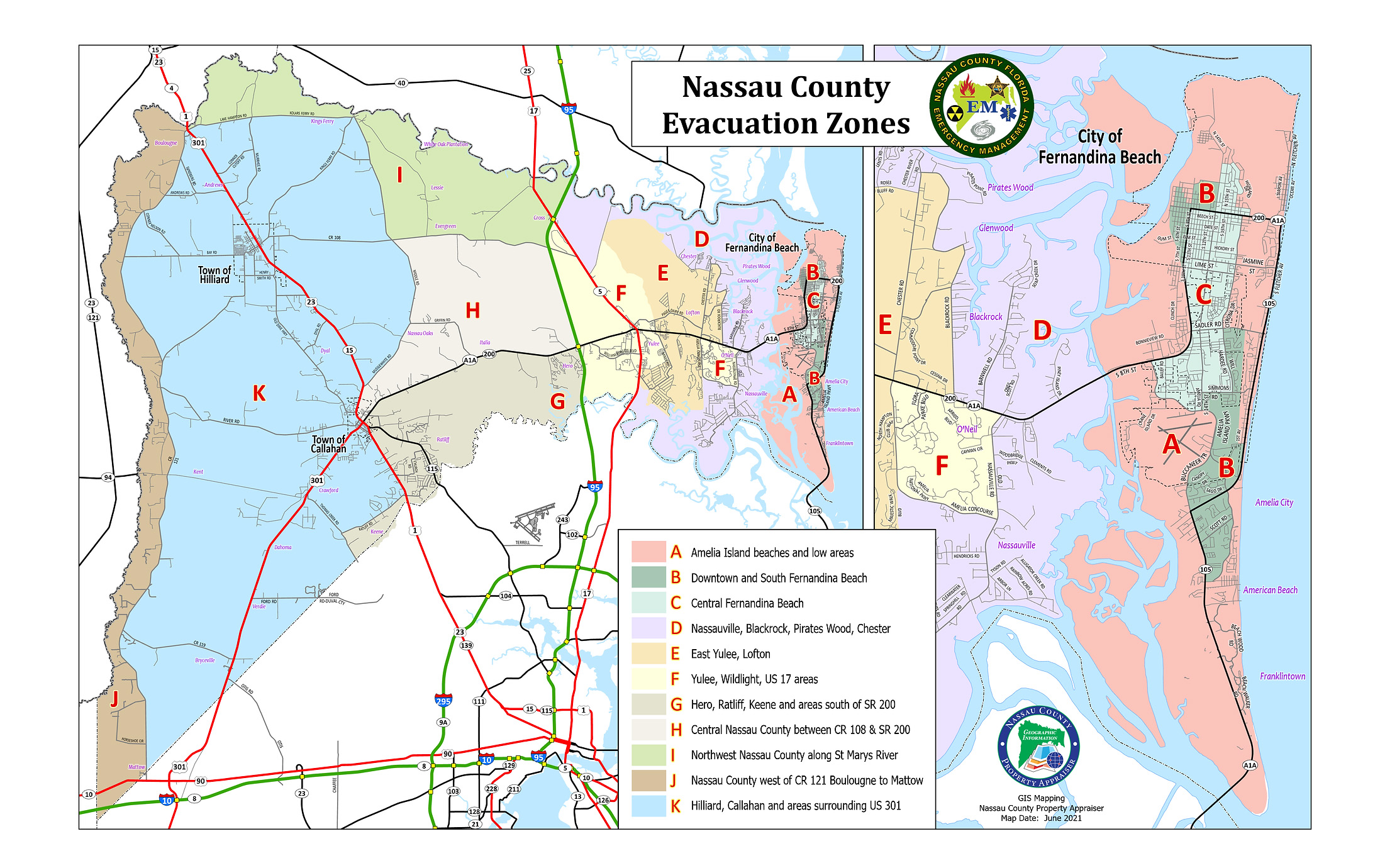
If this forecast remains accurate, it elevates our concern for multiple areas in both Zones A and Zone D. The projected surge has potential for water intrusion into homes during the high tide in the following areas:
Zone A: Egan’s Creek (Area), Crane Island (All), Long Point (All), 6th Street and Calhoun Street (Area), River Crossing Way (North of Bonnieview Road)
Zone D: Piney Island (All), Marsh Lakes (All), Holly Point (All), Brady Point (All), Oyster Bay(Area), River Marsh Bend (All)
If you reside outside of the areas listed above in Zone A or Zone D and have concern for your individual safety please evacuate.
If you do not have a safe location to shelter, a shelter is available at Wildlight Elementary, 550 Curiosity Ave, Yulee, FL 32097. This shelter will accept the general population, special needs residents, and pets with Rabies vaccinations.
To read a full copy of the Evacuation Order, click here https://www.onenassau.com/_files/ugd/b47643_c541878709a8436f909d81a91d7924e3.pdf
----
Oct. 9, 8:45 p.m.
The National Hurricane Center said Hurricane Milton made landfall at 8:30 p.m. "Doppler radar data indicates that the eye of (Hurricane Milton) has made landfall near Siesta Key in Sarasota County on the west coast of Florida. Max sustained winds at landfall are estimated at 120 mph."
----
Oct. 9, 7 p.m.
Nassau County posted a peak into the emergency shelter at Wildlight Elementary School on YouTube.
Nassau County School District is in charge of emergency shelter operations.
Nassau County Superintendent of Schools, Kathy Burns, said there are people utilizing the shelter operations, but did not say how many.
For more shelter information, visit Emergency Management's website: onenassau.com
----
Oct. 9, 5:05 p.m.
Hurricane Milton is now a Category 3 storm as the eye gets closer to making landfall.
As of 5 p.m. noaa.gov showed Milton had maximum sustained winds of 120mph; minimum pressure of 948 mb; moving northeast at 17 mph; located at 26.9N and 83.4W.
Tropical Storm Force winds are well into southwestern and central Florida, and there have been several reports of tornados. Much of southwestern and central Florida are under Tornado Warnings.
Forecasts say the storm will make landfall, between Tampa and Fort Meyers, most likely tonight in Sarasota County.
Forecasts expect that on Thursday most of Florida will have been affected by Milton.
The National Hurricane Center said life-threatening storm surge and hurricane-force winds are expected on the west Florida peninsula tonight.
----
Oct. 9, 3:25 p.m.
Nassau County held a news briefing Wednesday evening to update locals as well as to announce the closure of beach driving starting tonight.
County Manager Taco Pope said, "Tonight at 6 p.m., beach access for vehicles will close and will remain closed, until impacts can be assessed and then reopened. And so, if you planned to go and visit the beach, you will not be able to drive on with your vehicle."
Emergency Management Director Tim Cooper encouraged residents to follow the evacuation recommendations from earlier today. "What we would strongly encourage those residents to do is follow the message that was in that warning. We are expecting to see some impacts, not as bad as other people, but we will still see impacts..."
Cooper said it is particularly important for people in low-lying, flood-prone areas to take advantage of the shelter.
"We just want to make sure the community is safe, we don't want to have to send first responders out to help a situation that you could resolve yourself in Nassau County just by going to a friend's house or a shelter," Cooper said.
Cooper also responded to some resident's questions about why EM waits to announce the emergency shelter address. He said the county waited until the "last minute" because forecasts change.
"The last thing we want to do is early-message that storm location, and then something that storm does makes us have to change that," Cooper said. "And then that message has been shared hundreds of times ... so if we put that out and then have to change that, there is bad information out there..."
Cooper said the shelter will remain open until conditions are no longer dangerous for Nassau County residents.
He said call 904-548-0900 immediately if you need transportation to the shelter.
Fire Chief Brady Rigdon also was at the briefing. Rigdon said teams have been assembled to respond to road obstructions by the Sheriff's Office, the Fire Department and Road and Bridge and will be ready to respond as needed.
He also asked locals to not over-dial 911 in order to keep the lines open for emergencies.
"If you need 911, please give us a call, but if it's not an emergency, maybe delay ... or call a nonemergency number," Rigdon said.
For more information visit onenassau.com or call 904-548-0900.
---
Oct. 9, 2:30 p.m.
The Hurricane Center said tropical storm force winds were just off the shore of Florida's west coast at 1 p.m.,. and just short of an hour later said, "Milton Growing in Size as it Moves Closer to the West Coast of Florida. Life-Threatening Storm Surge, Damaging Winds, and Flooding Rains Expected Across Portions of Central and Southwestern Florida."
Hurricane Milton has dropped to a Category 4 and has moved a little bit south, but storm surge, strong winds, flooding from rain and widespread power outages are expected in Nassau County.
Forecasts say Milton's wind-field is expected to grow in size as the storm weakens before hitting the coast. The storm will make landfall, between Tampa and Fort Meyers, most likely tonight in Sarasota County.
Forecasts expect that on Thursday most of Florida will have been affected by Milton. Tornados are expected throughout much of Florida.
As of 2 p.m., noaa.gov showed the storm had maximum sustained winds of 130mph; minimum pressure of 944 mb; moving north-northeast at 16 mph; located at 26.3N and 84.0W.
---
Oct. 9, 11 a.m.
This morning, Nassau County Emergency Management strongly encouraged some island residents to shelter at a safe location or a designated shelter.
Based on the forecasted impacts of Hurricane Milton, the following residents received the evacuation recommendation:
- Individuals that have power dependent special needs
- Individuals who reside in low lying or flood prone areas
- Individuals in Zone A (more directly those who reside near dunes that could be breached, those who reside on marsh front or intracoastal front property - special attention to Crane Island and Egans Creek)
-Individuals in Zone D ( more directly those who reside on marsh front property or intracoastal front property - special attention to Piney Island and the Holly Point area)
- Individuals who do not feel safe at their place of residence
This was a recommendation and not an evacuation order.
EM said "If you do not have a safe location to shelter, a shelter is available at Wildlight Elementary, 550 Curiosity Ave, Yulee, FL 32097. This shelter will accept the general population, special needs residents, and pets with Rabies vaccinations."
EM said to bring the following items with you to the shelter: Blankets and pillows; clothing; mobility equipment; medications; food and snacks; and personal hygiene items
EM said pet owners should bring a secure crate; pet food and bowls; leash, collar or harness; litter box; and proof of rabies vaccination.
According to NOAA, strong winds are expected to begin in the area later this evening. For more information on Milton, visit www.nhc.noaa.gov/. For more information on local response efforts, visit www.onenassau.com.
----
Oct. 9, 8:15 a.m.
Nassau County announced the emergency shelter is now open.
"As of 8 am 10/9/24: Shelter is now open (at) Wildlight Elementary, 550 Curiosity Ave, Yulee, FL 32097. Shelter will accept the general population, special needs residents, & pets with Rabies vaccinations. Residents needing transportation to the shelter should call 904-548-0900," Emergency Management posted.
The National Hurricane Center said at 8 a.m. the National Weather Service "is forecasting a high risk of flash flooding from (Milton) with rainfall totals up to 18 inches over the Florida Peninsula. This rainfall brings the risk of catastrophic and life-threatening flash and urban flooding, along with moderate to major river flooding."
----
Oct. 8, 9:35 p.m.
Hurricane Milton's forecasted path has shifted throughout its’ journey toward Florida's west coast. Nassau County expects to see storm surge, strong winds, flooding and wide-spread power outages as a result of the storm, but all forecast show it crossing the entire peninsula of Florida at hurricane strength.
The National Hurricane Center has repeatedly warned of the danger of the Category 5 storm. Milton began relatively quickly with a potential Wednesday morning arrival. The storm has since slowed, and even dropped to a Category 4 Tuesday, before returning back to Category 5 strength.
The National Weather Service said Tuesday night, “With the sun setting on the now Category 5 Hurricane (Milton), we'll offer these words from the (National Hurricane Center) forecast discussion… ‘"This is a very serious situation and residents in Florida should closely follow orders from their local emergency management officials. Evacuations and other preparations should be completed today. Milton has the potential to be one of the most destructive hurricanes on record for west-central Florida."’
Nassau County Emergency Management (EM) gave an update from 5 p.m. “Major Hurricane Milton has regained category 5 strength winds. Milton is on track to bring significant impacts to NE FL & Coastal SE GA Wednesday into Thursday. The greatest impacts are expected Wednesday afternoon into Thursday morning. Hazards include: Damaging winds, storm surge, flooding, river flooding & dangerous beach/marine conditions.”
Emergency Management announced a few evacuation recommendations Tuesday morning. EM said, “Nassau County is forecast to be impacted by flooding rainfall, and storm surge of 3-5 feet above normal as the storm crosses the Florida peninsula and moves away from our coast Wednesday and Thursday. In preparation, we are strongly encouraging residents who reside in the following areas to relocate to safer locations: Zone A; Zone D; Beachfront, intracoastal and marshfront areas; Low-lying and flood-prone areas.
EM said preparations are in progress to open a shelter on Wednesday and the location would be announced soon.
No other evacuation orders or curfews have been issued for Nassau County but it is in a Storm Surge Warning, a Tropical Storm Warning, a Hurricane Watch and a Flood Warning.
Nassau County will continue sandbag operations Wednesday. The county said sandbags still will be available from 7 a.m. to noon. Wednesday at the following locations: Yulee Ballpark, 86142 Goodbread Road in Yulee; Hilliard Road Department, 37356 Pea Farm Road in Hilliard; and Yulee Road Department, 86200 Gene Lasserre Blvd. in Yulee.
Early forecasts prompted closures around the city and county for Wednesday and Thursday including Nassau County government buildings, City of Fernandina government buildings and Nassau County School District.
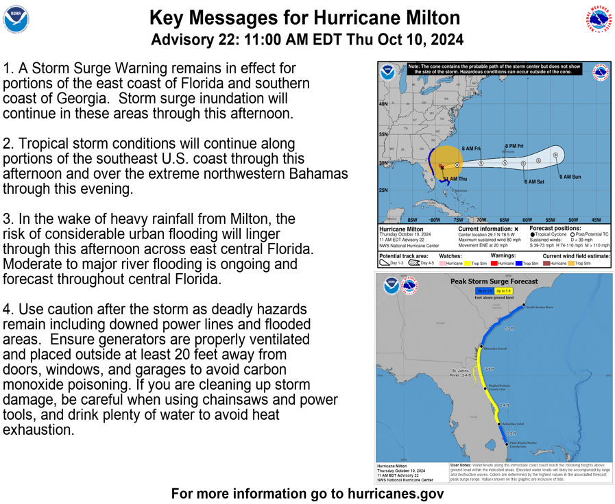
POST-TROPICAL CYCLONE MILTON. NATIONAL HURRICANE CENTER and CENTRAL PACIFIC HURRICANE CENTER
Hurricane Milton live tracker from the News-Leader.
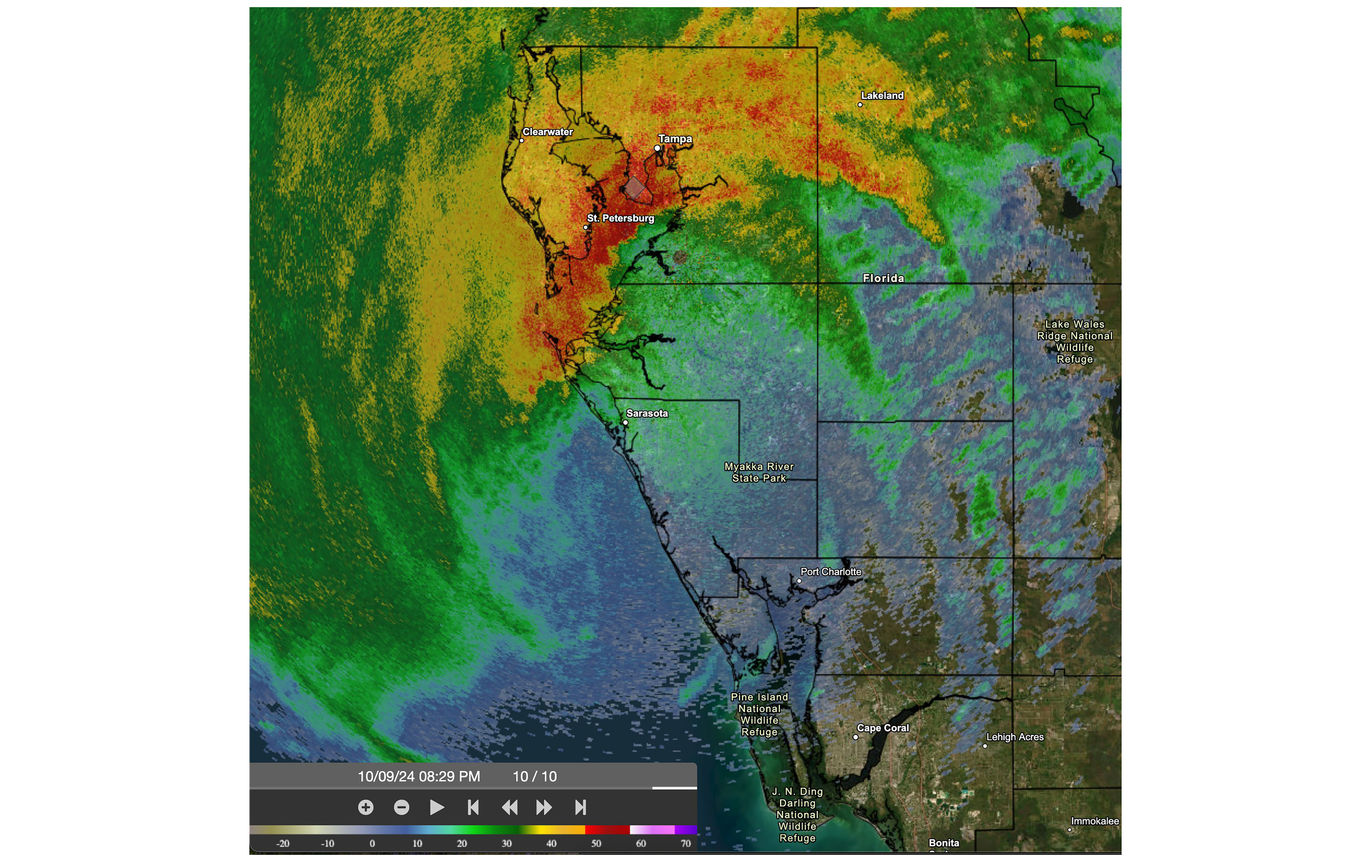
The National Hurricane Center shared this image at the time Hurricane Milton's eye made landfall. The National Hurricane Centers said: "830pm EDT Oct 9th: Doppler radar data indicates that the eye of #Hurricane #Milton has made landfall near Siesta Key in Sarasota County on the west coast of Florida. Image by NOAA
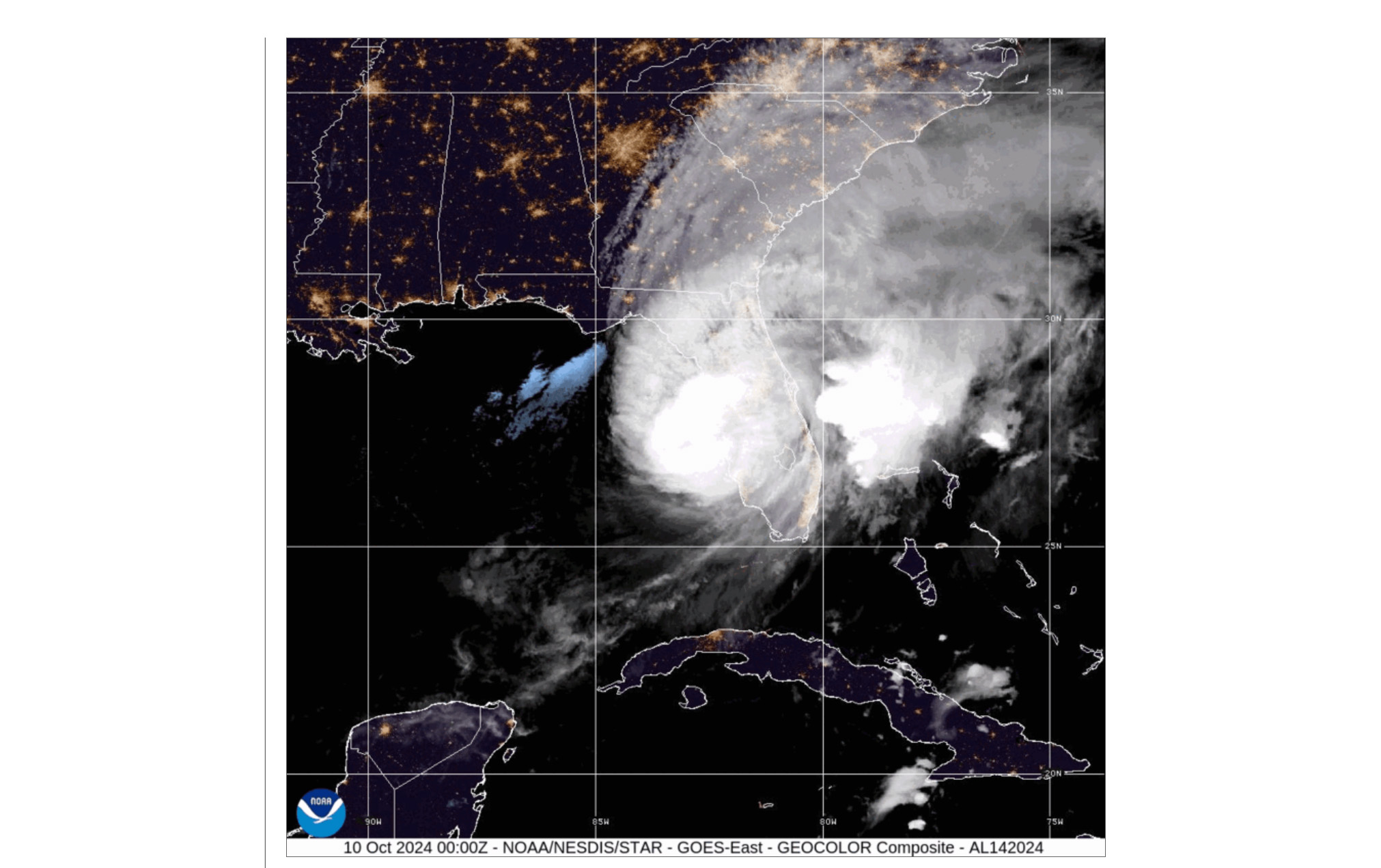
This GeoColor image made by NOAA shows where Hurricane Milton will be shortly after midnight. During the day, the imagery looks approximately as it would when viewed with human eyes from space. At night, the blue colors represent liquid water clouds such as fog and stratus, while gray to white indicate higher ice clouds, and the city lights come from a static database derived from the VIIRS Day Night Band.
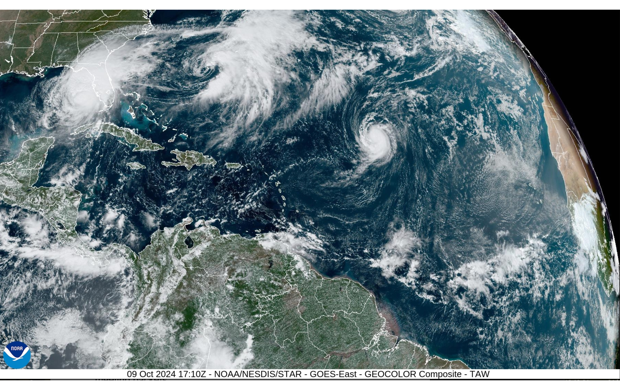
This NOAA image shows the Atlantic Ocean midday Wednesday. In the top left corner of the image, Hurricane Milton can be seen just off the west coast of Florida. Image by NOAA
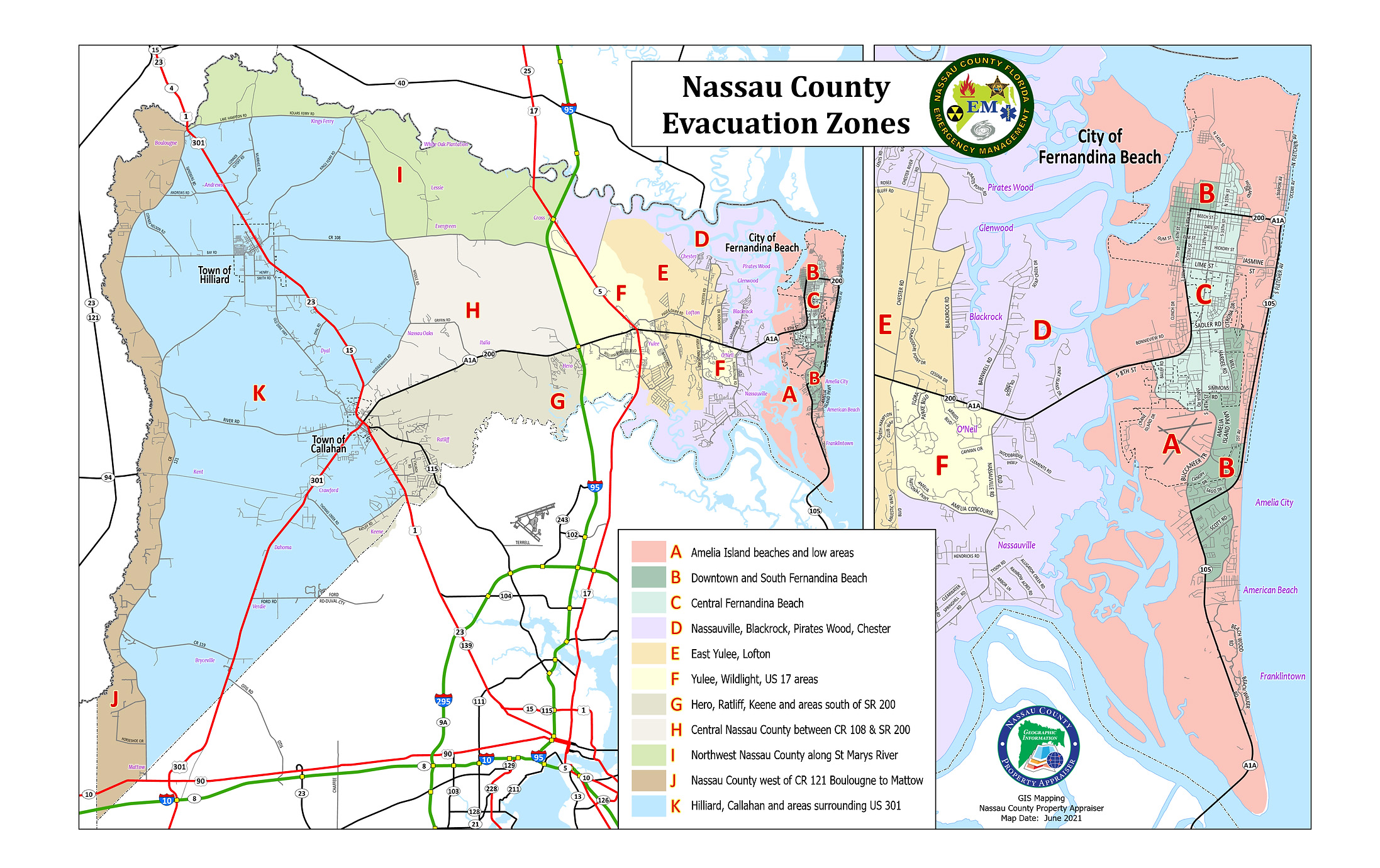
Nassau County Emergency Management shared these evacuation zone maps Tuesday ahead of Hurricane Milton landfall, now expected sometime between Wednesday evening and Thursday morning.
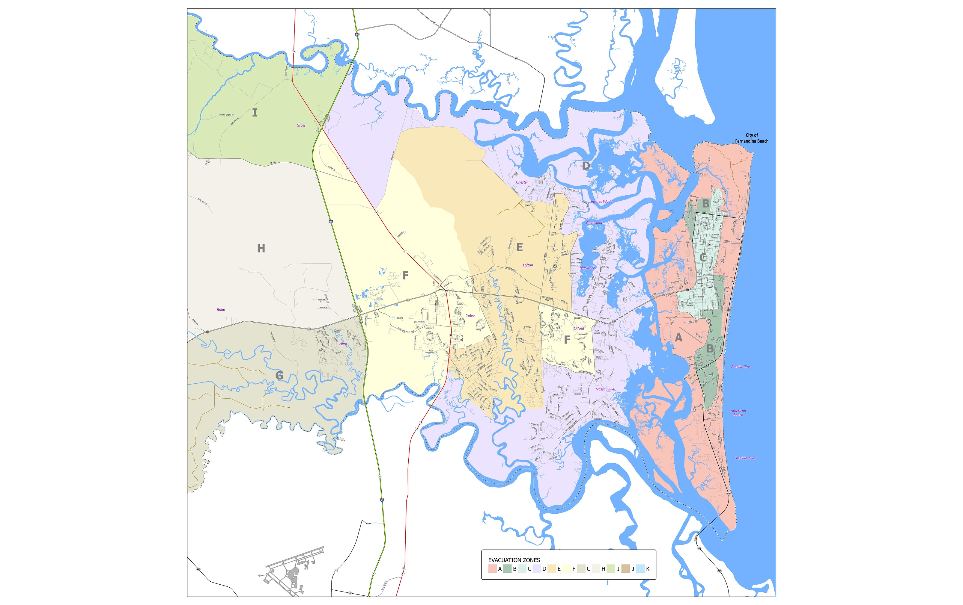
Nassau County Emergency Management shared these evacuation zone maps Tuesday ahead of Hurricane Milton landfall, now expected sometime between Wednesday evening and Thursday morning.
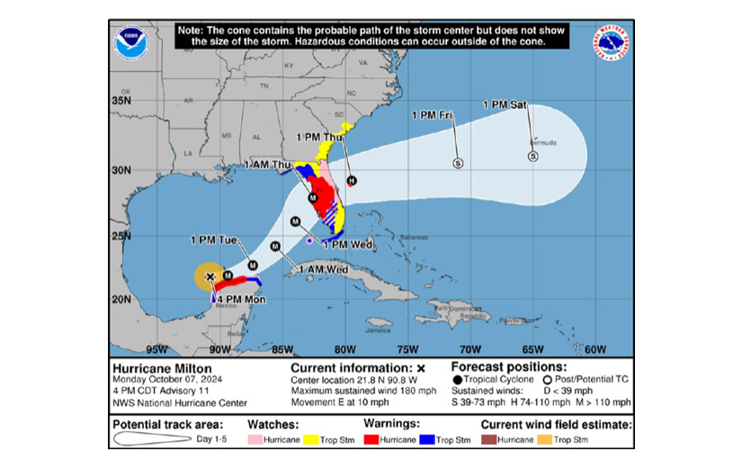
This graphic shared by city of Fernandina Beach Interim City Manager Jeremiah Glisson showing the potential path and timeline Hurricane Milton will take as of Tuesday midday.