

Latest updates on Hurricane Helene
Sept. 28, 4:15 p.m. — Interim City Manager Jeremiah Glisson announced that city staff have cleared all roadways after Hurricane Helene. They will temporarily shift from the regular yard waste collection to focus on removing storm debris, which is expected to take a few weeks. He thanked the community for their patience during this cleanup effort.
As a reminder, he said:
-
Storm debris should be piled and placed at the edge of your yard for pick-up.
-
Do not mix vegetative debris with trash.
-
If you choose to bag your storm debris, you must use biodegradable bags.
-
Do not place vegetative debris in containers, on or near storm drains or other obstructions (hydrants, electrical boxes, under low limbs, etc.).
If you have any questions, please contact Fernandina Beach Public Works at yardwaste@fbfl.org
---
Sept. 27, 4 p.m. — Nassau County announced shortly after noon that beach driving at Peters Point, Scott Road and American Beach were reopened. No time was wasted, as a vehicle could already be seen on the American Beach sand before 1 p.m.
The county also said "please be advised that power is out at Peters Point and Burney Park so there is no electricity in the restrooms," and "please take notice of flags at the beach for tide and surf conditions and follow them for your safety."
The county said at 10:30 a.m that crews still were out clearing debris, but informed residents that debris on private property would not be disposed of by the county.
"Residents are advised to separate their household and yard debris and dispose of it through normal channels. Please contact your garbage service provider directly with questions. Excess yard waste should be cut and bagged according to waste-removal providers’ guidelines," the county said. "Residents of local municipalities should follow city and town debris disposal procedures."
The county advised locals that excess yard waste and construction/demolition debris can be taken to Sandhill Recycling Center at 153326 CR-108 in Yulee for a fee.
The county also said the Convenience and Recycle Center will be open on Saturday from 8:30 a.m. to noon. "Please note that this site is not permitted to take yard or construction debris. This site accepts normal household waste for disposal and only paper, cardboard, glass, metals, plastics, tires, electronics and latex paint for recycling," the county said.
The Nassau County Emergency Management Emergency Operations Center has downgraded to "Activation Level 2." For emergency updates and post-storm advice, visit EM's facebook page.
According to poweroutage.us, 759,792 Florida customers still are without power, and 7,350 are without power in Nassau County.
---
Sept. 27, 8 a.m.— Hurricane Helene roared ashore late Thursday night, slamming into Florida's Big Bend region as a Category 4 storm before rapidly losing steam as it moved inland. The hurricane's brief but intense impact left a trail of destruction in its wake, with over 2 million residents across five states left without power.
Helene made landfall at 11:10 p.m. EDT Thursday, just 10 miles west of Perry, Fla., packing sustained winds of 140 mph. However, the storm's fury was short-lived. By 5 a.m. Friday, Helene had been downgraded to a tropical storm, its winds diminished to 70 mph as it raced northward at 30 mph.
"This marks the fourth hurricane to strike the Gulf Coast this year, a phenomenon we've only seen five other times in recorded history," noted Stephanie Abrams, meteorologist for The Weather Channel, during a Friday morning broadcast.
Despite its swift weakening, Helene's impact was immediately felt across the region. Florida bore the brunt of the power outages, with 1.2 million customers plunged into darkness. Georgia wasn't far behind, reporting 840,000 outages, while South Carolina, North Carolina, and Virginia collectively added another 752,000 to the tally, according to utility tracker PowerOutage.us
Florida Governor Ron DeSantis confirmed one fatality in the Tampa area, where a falling traffic sign fell on a vehicle.
As Helene continues inland, authorities warn that the danger is far from over. The National Hurricane Center cautioned that the storm still poses a "life-threatening" risk of storm surge, high winds, and heavy rainfall.
Governor DeSantis announced that 3,500 National Guard troops stand ready to assist in emergency operations. Meanwhile, the storm's approach forced the closure of several airports, with airlines canceling nearly 1,300 flights on Thursday. As of early Friday morning, over 600 additional U.S. flights had already been cancelled.
As residents from Florida to Virginia brace for Helene's ongoing impact, officials urge caution and adherence to local emergency guidelines.
---
Sept. 27, 1:15 a.m. Nassau County — Nassau County Emergency Management said at 12:45 a.m that numerous requests and notifications for powerlines and trees down as well as roadway obstructions are being received. EM said crews are working diligently to remove tree debris and powerlines from the roadways to ensure safe access. "Call 904-548-0900 to report lines and trees down, and roadway obstructions," EM said.
There are 1,279,981 without power in Florida and 25,764 people without in Nassau County according to the map on poweroutage.us.
The National Hurricane Center said at 1:05 a.m. the eyewall was entering southern Georgia. The map shows 193,582 without power in Georgia.
---
Sept. 27, 12:25 a.m. Nassau County — More than 10,000 customers are without power in Nassau County. According to poweroutage.us, 1,163,226 customers in Florida are currently without power and 10,191 are without power in Nassau County.
---
Sept. 26, 11:45 p.m. Nassau County — Over a million people in Florida and 5,000 in Nassau County are without power. According to poweroutage.us, 1,056,342 customers in Florida are without power and 5,272 are without power in the county.
---
Sept. 26, 11:27 p.m., Florida — The National Hurricane Center reported via social media platform X that Hurricane Helene had made landfall in the Florida Big Bend region at around 11:10 p.m. just east of the mouth of the Aucilla River. Max sustained winds at landfall were estimated at 140 miles per hour and a minimum pressure of 938 millibars, the post said.
Landfall is not considered official until at least half of the eye comes ashore.
---
Sept. 26, 11:20 p.m. Florida — Florida has 927,176 power outages according to poweroutage.us.
---
Sept. 26, 11:10 p.m. Nassau County — Nassau County Emergency Management posted that Hurricane Helene made landfall at approximately 10:45 p.m. in the Florida Big Bend Region near Keaton Beach in Taylor County.
EM said the outer bands of the storm have been pushing through Nassau County and have brought rain and winds.
"We are already receiving multiple reports of trees and power lines down across the county. Please stay off the roadways and indoors while the storm pushes through," the post said.
EM said to report any power lines down and trees down to the EOC at 904-548-0900 and any storm damage by using the OneNassau Storm Damage Reporting tool.
---
Sept. 26, 10:58 p.m., Florida Big Bend — The National Hurricane Center said Hurricane Helene is very close to making landfall in the Florida Big Bend, accompanied by a catastrophic storm surge and life-threatening winds.
---
Sept. 26, 10 p.m., Florida Big Bend — The National Hurricane Center posted an update that Helene's eyewall was beginning to move ashore along the Florida Big Bend region.
Florida has over 700,000 power outages according to poweroutage.us.
---
Sept. 26, 8:15 p.m., Nassau County — Nassau County Emergency Management posted some safety information on social media and said that the worst of the storm impacts are expected in the overnight hours.
The post said there is no curfew in place but "it is highly advised that all residents and visitors of Nassau County take shelter and remain indoors." The post said, do not drive during poor weather conditions unless absolutely necessary.
The post also advised to call 911 in the event of an emergency.
---
Sept. 26, 8 p.m., Nassau County — Nassau County Emergency Management announced that a tornado watch is in effect until 6 a.m. Friday for Nassau County and surrounding counties.
---
Sept. 26, 6:30 p.m., Nassau County — Emergency Management gave an update: "Hurricane Helene’s path has continued to slowly move towards the east. Because of these changes we are expecting strong tropical storm force winds across all of Nassau County.
Conditions are deteriorating now and will continue to decline with the worst of the impacts expected in the overnight hours. Please take this time to get to your place of shelter and remain indoors until the storm passes. If your current situation does not meet your needs there is still time to get to the shelter."
Nassau County's shelter is located at Wildlight Elementary School, 550 Curiosity Ave in Yulee.
There currently are no evacuation orders for Nassau County.
---
Sept. 26, 6:20 p.m., Northeast Florida — National Hurricane Center said Helene is now "an extremely dangerous Category 4 hurricane." The group's social media post said, "A NOAA Hurricane Hunter aircraft currently investigating Helene recently found that the maximum sustained winds have increased to 130 mph (215 km/h). The minimum central pressure has also decreased to 947 mb (27.96 inches) based on dropsonde data."
---
Sept. 26, 5:44 p.m., Florida — Governor Ron DeSantis in a press conference gave updates ahead of Hurricane Helene's landfall.
"The storm is currently about 125 miles west of Tampa, about 175 miles south of Tallahassee. It does look like the storm will strengthen as it prepares to make landfall later this evening," DeSantis said.
He said most of the data Florida has shows a landfall in Taylor County, Florida later this evening. DeSantis advised residents to abide by evacuation orders, and said you still have time to evacuate.
"In other parts of Florida, listen to your emergency managers," he said.
He also warned to treat falling limbs as a tornado and "shelter in a part of the home you would have protection from that," and he said to be aware that the conditions can cause tornados.
State leaders said do not go out, do not drive, stay put until the storm passes.
DeSantis was joined by Major General John D. Haas; Florida Division of Emergency Management Executive Director Kevin Guthrie; Colonel Gary Howze of the Florida Highway Patrol; and Florida Department of Transportation Secretary Jared Purdue at the State Emergency Operations Center to give updates on the state's plan of action ahead of Helen's landfall.
You can view the full press conference on DeSantis' X page, x.com/GovRonDeSantis.
For more information view the full press release: Governor Ron DeSantis Issues Updates on Preparedness Efforts and Response to Hurricane Helene.
---
Sept. 26, 5:30 p.m., Nassau County — Nassau County announced public offices and facilities would remain closed Friday, and said Public Works and essential personnel will be working on storm damage and recovery. The county said sandbag operations will resume Friday at noon through 7 p.m. at the following locations: Yulee Road Department, 86200 Gene Lasserre Boulevard; Yulee Ballpark, 86142 Goodbread Road; Hilliard Road Department, 37356 Pea Farm Road.
The county also announced that beach driving is temporarily suspended starting at 6 p.m. Thursday, including county beaches, Peters Point south to the State Park, and the segment of City Beach by Seaside Park and Slider's.
---
Sept. 26, 11:30 a.m., Fernandina Beach — Mayor Bradley Bean gave an update through a video posted on the City of Fernandina Beach Government's Facebook page.
---
Hurricane strengthens before Florida landfall, bringing storm surge and flooding
As Hurricane Helene bears down on Florida's Gulf Coast, residents and officials are bracing for what could be one of the most devastating storms to hit the state in recent years.
"We're looking at a potentially catastrophic event," said meteorologist Dr. Sarah Johnson of the National Weather Service. "Helene is intensifying rapidly and could make landfall as a major Category 3 hurricane or stronger."
Currently located 255 miles southwest of Tampa, Helene is churning northward at 14 mph with sustained winds of 105 mph. The sheer size of the storm, with tropical-storm-force winds extending up to 345 miles from its center, has meteorologists particularly concerned.
Nassau County has put out several updates to residents as Hurricane Helene is expected to head to the east.
The Pages Dairy and Chester Road intersection has been reopened. In a video posted by the county Thursday morning, Director of Strategic Advancement Brandy Carvalho gave some updates and said, “The crews worked into the middle of the night to get that opened to you.”
An emergency shelter also was opened this morning in Wildlight at 8 a.m. It is located at Wildlight Elementary School - 550 Curiosity Ave - Yulee, FL 32097.
Nassau County Emergency Management (EM) said the shelter is available to any power dependent special needs person, individuals in flood prone and low lying areas, and those who may be displaced due to recent heavy rains. The shelter is capable of providing service for special needs, general population and is pet friendly.
EM said if transportation is needed please contact the EOC at 904-548-0900 to arrange a ride. EM also said, you can use the promo code “HELENERELIEF” on Uber to get free rides to shelter locations.
County sandbag operations were available until noon today, and self-serve sandbag sites are located at Yulee Ballpark, 86142 Goodbread Road, and Hilliard Road Department, 37356 Pea Farm Road. The county previously stated sand was outside the gate and accessible at all times at Yulee Ballpark; and sand is behind the gate and will be accessible from 7 a.m. to 7 p.m. at Hilliard Road Department.
County public offices and the county public buildings closed at noon, but staff will still be “doing storm preparation and response and recovery.” Carvalho said. Nassau County Schools also will be closed Thursday and Friday.
Emergency Management posted around 10 a.m. that “recent forecast updates have indicated a slight shift in Hurricane Helene’s track to the east. With that, we are expecting an increase in the level and duration of tropical storm force winds in Nassau County.”
At 11 a.m., EM posted that a tornado watch would be in effect for Nassau County until 10 p.m. today. “Know where your safe place is and be ready to move,” the post said.
EM also posted around 11 a.m. that “conditions in Nassau County are expected to slowly deteriorate over the next several hours with tropical storm force winds expected throughout the evening and into the morning.”
“There are currently no evacuation orders for Nassau County, however, we encourage all persons that are power dependent special needs or in flood prone areas to shelter at a safe location that meets your specific needs,” the post said.
Follow Emergency Managements facebook page or visit www.onenassau.com for updates.
Wednesday, Nassau County held a press conference giving updates on the storm where they initially announced the shelter activation and gave more information on how operations work. The press conference from Wednesday and the update from Carvalho Thursday morning can be viewed on county’s YouTube page: https://www.youtube.com/@nassaucounty3018.
Nassau County declared a Local State of Emergency on Monday, in preparation for Hurricane Helene.
Governor Ron DeSantis issued a State of Emergency earlier the same day for several counties in Florida, but excluded Nassau County. Nassau County had been in contact with state leaders and made the county declaration in anticipation of the state expanding the declaration to include Nassau. The state did expand its State of Emergency to include Nassau County and several other Florida counties.
Fernandina Beach followed suit and declared a Local State of Emergency on Tuesday.
Nassau County says residents with questions or concerns should contact the EOC call center at 904-548-0900.
Tornado watches have been issued for much of the Florida Peninsula, southern Georgia, and parts of South Carolina.
The timeline for Helene's impacts is rapidly narrowing. The storm is expected to reach its peak intensity Thursday night before making landfall along Florida's Big Bend. By Friday, Helene will be sweeping through the Southeast, potentially bringing damaging winds and flooding rains as far north as the Ohio Valley.
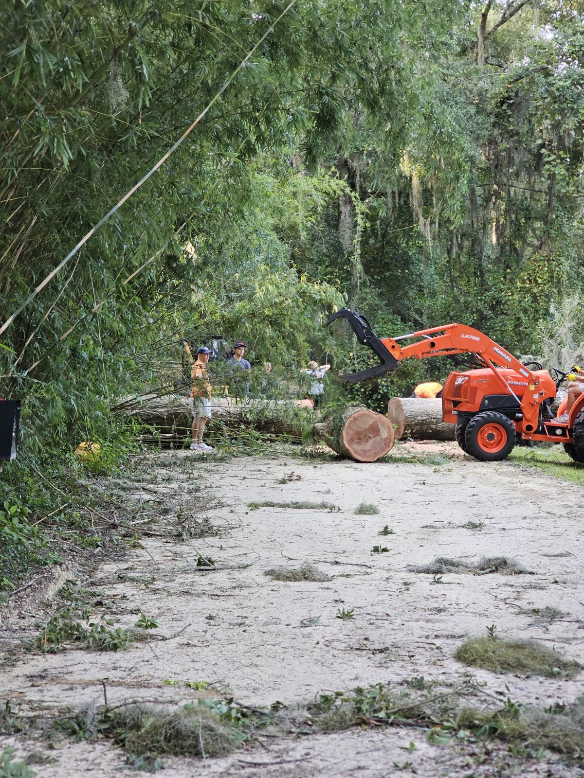
Taken by News-Leader Publisher, Foy Maloy, on Glenwood Road, off Blackrock Road in Yulee. "These fallen trees stripped the power lines down," said Maloy.
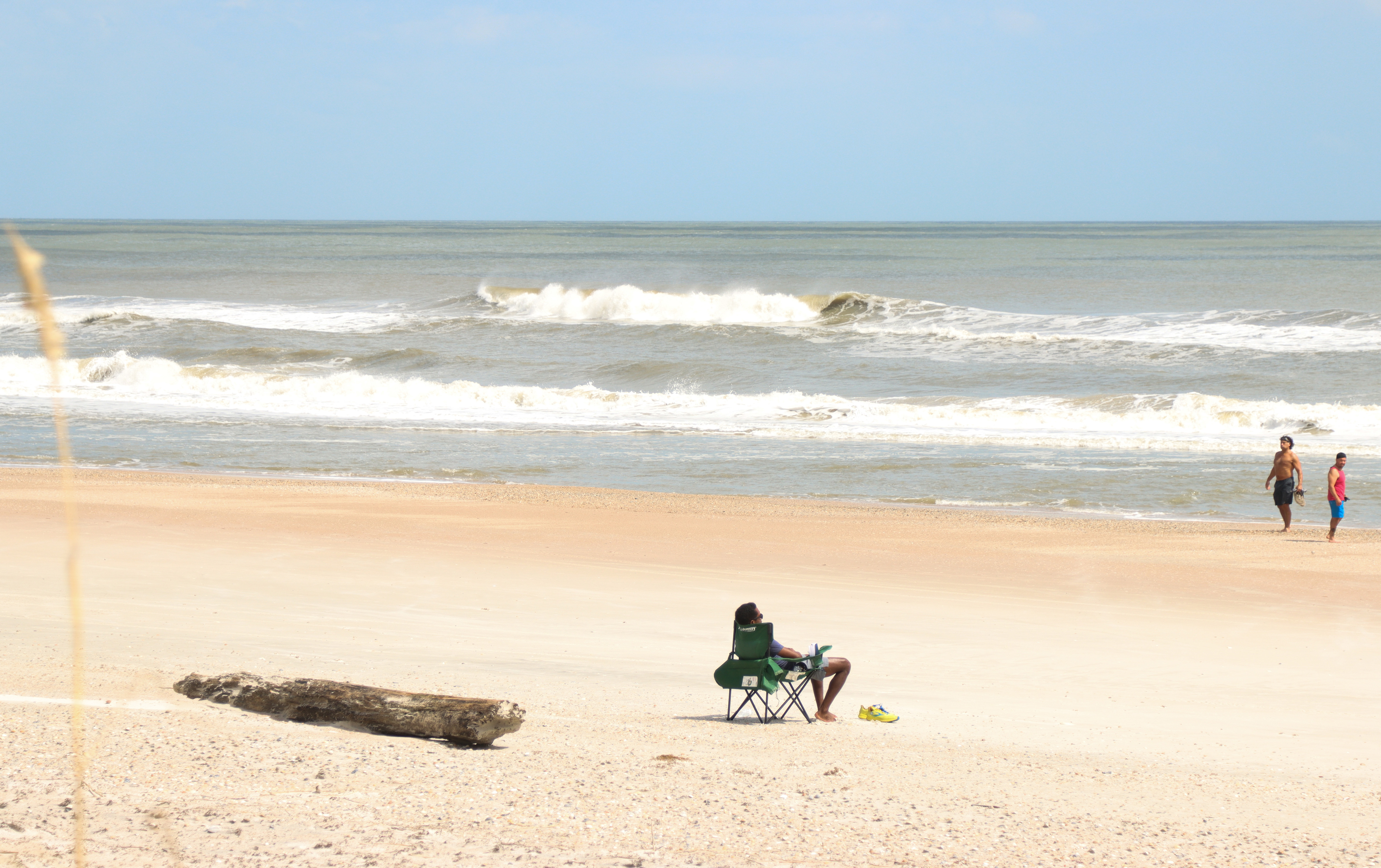
American Beach conditions around 12:45 p.m. today. Nassau County announced shortly after noon that beach driving at Peters Point, Scott Road and American Beach were reopened. Photo by Ashley Chandler/News-Leader
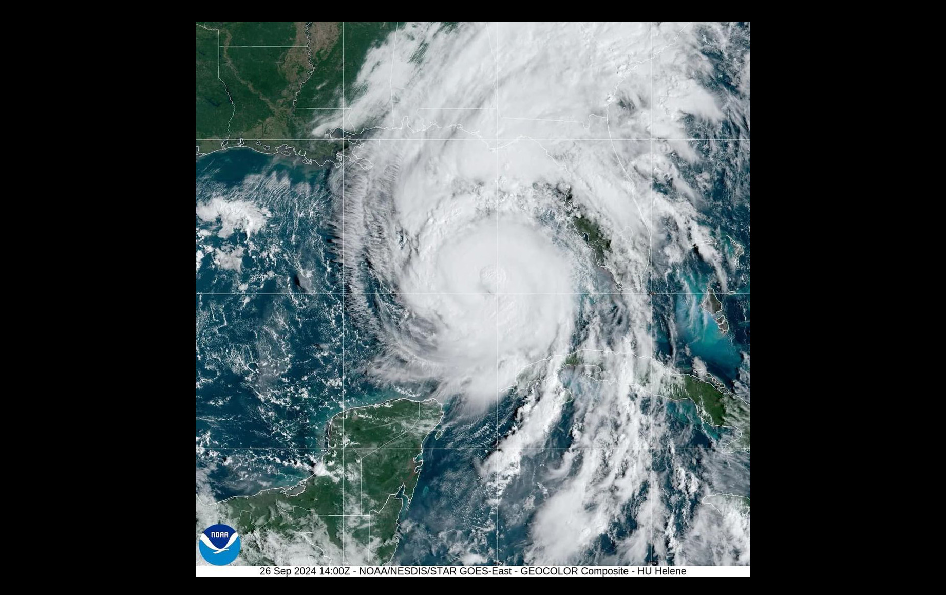
Image by NOAA on Thursday.
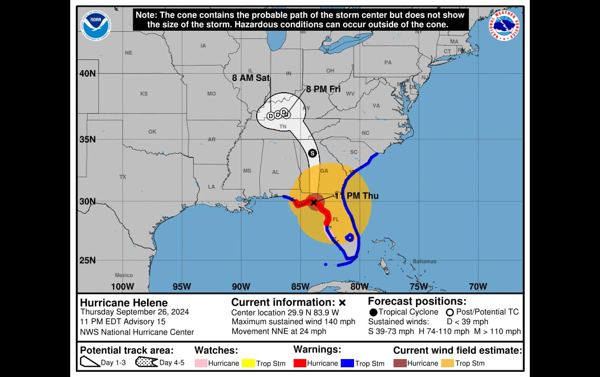
Nassau County Emergency Management posted this photo alongside a social media post that said Hurricane Helene made landfall at approximately 10:45 p.m. in the Florida Big Bend Region near Keaton Beach in Taylor County.
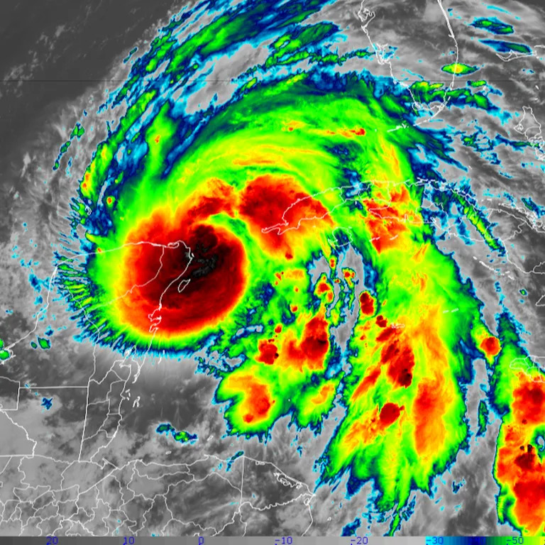
National Weather Service image as Helene made landfall at 11:10 p.m. EDT Thursday, just 10 miles west of Perry, Fla., packing sustained winds of 140 mph.
Tracking Hurricane Helene. News-Leader