

BOCC declares local state of emergency:
Story by Marissa Mahoney/News-Leader
In anticipation of Hurricane Ian’s arrival later this week, the Board of County Commissioners (BOCC) declared a “state of local emergency” at the insistence of County Manager Taco Pope and Emergency Management Director Tim Cooper.
At the start of the Sept. 26 BOCC meeting, Pope requested to expand on the night’s previously established agenda to make his request.
“I would request that we expand the agenda to include a brief update on Hurricane Ian from Nassau County Emergency Director Tim Cooper, and then request that the Board of County Commissioners a local state of emergency in response to said hurricane,” Pope introduced.
The commissioners then invited Cooper – a 27-year veteran with the Nassau County Sheriff’s Office – to speak on behalf of the county’s Emergency Management (EM) department.
“We’ve been prepping for this, really, for months and months, but more steadily in the last week, of course. We’ve been watching this from the time it was a tropical depression nine. The only thing that is certain about the forecast right now is the uncertainty, as we all know. We do know with high certainty that we’re going to have major weather impacts as far as rain. They’re giving the example that it’s going to be very close to what we saw in (Hurricane) Irma.”
Cooper added that EM has plans in place to monitor wind activity and will release information about that as deemed necessary.
“I’d like to ask for you all to go ahead and declare a local state of emergency so it opens up all our resources. We need to prepare and protect our citizens,” Cooper concluded.
In response, BOCC Chairman Jeff Gray of District Three said, “I know we’ll be working hand-in-hand with public safety to do whatever we need. If you need anything from the commissioners, please give us a call and contact the county manager. We’ll be glad to assist you in any way we can.”
District 2 Commissioner Aaron Bell took this opportunity to ask Cooper about how wind speed will impact the Thomas J. Shave Jr. Bridge connecting the mainland to Amelia Island.
Cooper responded that the Shave Bridge will be temporarily shut down if there are 39 miles per hour sustained winds.
“If we get to hurricane level winds and there’s some threat that there may have been some structural damage, then we have to have engineers look at that before we can have that back up for the safety of the public crossing that bridge,” Cooper said.
He elaborated that although this policy is in place, Cooper doesn’t “any of that” with Hurricane Ian.
“We never say never, but we have plans in place if that happens. We’ll get our core engineers out here. Most of the time they’re here within 12 hours of the storm passing, but we have no expectations at this time based on the current forecast as we see it,” Cooper acknowledged.
Cooper elaborated that they don’t anticipate a sustained shut down of the Shave Bridge, but there may be temporary closings depending on wind speed.
After Cooper’s speech, the commissioners unanimously voted to put Nassau County in a local state of emergency ahead of Hurricane Ian.
mmahoney@fbnewsleader.com
Statement from City Manager Dale Martin:
As Hurricane Ian moves past Cuba, it is important to consider your preparation and response to the storm while time is still available. Please note that information about Hurricane Ian in this article is based upon the current data at the time of writing (6:00 AM, Tuesday).
The northeast coast of Florida is currently under a Tropical Storm Watch. Although the National Hurricane Center (NHC) projects a landfall in the vicinity of Tampa early Thursday morning, the stronger winds associated with the storm will likely begin to be felt in our area Wednesday evening. The NHC probabilities show a 60-70% chance of winds of at least 40mph.
With those high winds, secure outdoor furniture and equipment that could be susceptible to being propelled to create other damages or injuries. Construction sites are required to secure on-site material and dumpsters.
The NHC projections show that after making landfall, the storm will continue inland to the northeast before shifting to a northern track, likely passing to the west of Nassau County before moving into Georgia. This projected track makes our area vulnerable to storm surges and heavy rains. It is likely that we will have to deal more with the effects of water than the effects of wind.
Many areas of the City flood somewhat easily during otherwise heavy rains, other storms, or high tides. Expect flooding in those areas as well as other areas on the island as well as on the mainland. The County has revised evacuation zones, so please familiarize yourself with those new designations (ranging from A-K; see https://maps.nassauflpa.com/NassauTaxMap/#, click Map Layers [top menu bar], then Public Safety [left menu]). In general, the City evacuation zones are A, B, and C.
The projected storm surge is indicated as up to six feet. Given the combined effect of a storm surge with the usual high tides, it is likely that vehicles will be prohibited from accessing the beach parking area at Seaside Park (Sadler Road) during the storm, possibly as early as Thursday.
The bridges onto the island may be closed to traffic due to high winds (sustained winds of 40mph or greater). County officials determine when such closures are necessary. Contrary to social media myths, the bridges are not closed at a specified planned time (and to debunk another social media myth- Florida Public Utilities does not intentionally turn off the power to the island).
For accurate information about the storm and emergency response activities, I encourage you to visit the County Emergency Management website (www.OneNassau.com) and social media outreach (Facebook: www.facebook.com/NassauEM; Twitter: www.twitter.com/NassauEM). Please uses these sources for reliable information during this and any other emergency.
The City has declared a State of Emergency, effective at 12:01 AM, Tuesday. The principal reason for the State of Emergency is to make the City eligible for costs associated with preparation and recovery should a formal disaster declaration be announced. City and County staff will prepare damage assessments to submit to state and federal officials to support, if appropriate, a disaster declaration.
During the storm and in its immediate aftermath, please refrain from venturing out to sightsee and gawk. City and County crews may be working to provide care and clear dangers where needed. Down trees often mask tangled power lines. Flooding on roads may be deeper than apparent. If conditions warrant, the City, as part of its emergency powers, may declare a curfew. At this time, City operations are planned to continue throughout the storm.
We have been fortunate recently in having been minimally impacted by storms and hurricanes that have damaged or crippled other Florida communities. Please take the necessary precautions for your safety and the protection of your property.
Statement #1 from Emergency Management:
Nassau County is continuing to monitor Hurricane Ian. While it’s still too early to determine the exact impacts of the storm locally, preparations are taking place to ensure we are ready. At a minimum, Nassau County is expected to receive heavy rains and flooding.
Nassau County residents living in low-lying and/or flood-prone areas should begin preparing now. The County will have sandbags available at two locations:
-
Yulee Road Department: 86200 Gene Lasserre Boulevard, Yulee, FL 32097
-
Hilliard Road Department: 37356 Pea Farm Road, Hilliard, FL 32046
Both sites will be open beginning at 12:30 p.m. today and will close at 7:00 p.m. tonight. Following today, sites will be open from 7:00 a.m. – 7:00 p.m. until further notice.
Hundreds of bags are pre-filled and available on a first-come, first-served basis. Once the pre-filled bags are gone, residents will need to fill their own bags. Please bring a shovel. Must provide proof of residency.
If you have any questions, please contact Nassau County Emergency Management at (904) 548- 0900.
Statement #2 from Emergency Management:
As of 5:00 p.m. Monday evening, Nassau County has been placed under a Tropical Storm Surge Watch. This means that Nassau County could experience high tides and storm surge as a result of Hurricane Ian. Residents should prepare now by checking disaster supplies and ensuring you have an evacuation plan in place.
Please note that a Storm Surge Watch is different that a Storm Surge Warning. Right now, residents are reminded to stay vigilant and have a plan in place. Should a Storm Surge Warning be issued, Nassau County residents in low-lying and flood prone areas should prepare by placing sandbags around doors and garage doors, elevating or anchoring utilities, elevating furniture and clearing gutters of debris.
No announcements have been made regarding evacuations or sheltering. However, please be assured that plans are in place and will be announced should the need arise.
Know your evacuation zone! Should Nassau County be upgraded to a Hurricane Warning, evacuation orders will be announced by zone. You can find an evacuation zone map by visiting https://www.onenassau.com/evacuations/.
If you have not yet signed up for Emergency Alerts, please do so ASAP. This will ensure that you are notified right away if any evacuation orders are issued. Sign up at https://www.onenassau.com/citizens-alerts/.
If you have any questions, please contact Nassau County Emergency Management at (904) 548-0900.
Statement #3 from Emergency Management:
At the Board of County Commissioner’s meeting last night, the Board approved Resolution No. 2022-188 declaring a local State of Emergency in Nassau County, in preparation of Hurricane Ian.
Florida Statutes, Section 252.38, states that “safeguarding the life and property of (the County’s) citizens is an innate responsibility of the governing body of each political subdivision of the State” and further grants the County the power to provide a State of Emergency for the health and safety of persons and property”. The State of Emergency will apply to all territory within the legal boundaries of Nassau County, including the unincorporated and incorporated areas.
Declaring a local State of Emergency allows your government officials quick access to resources to help manage a crisis until things return to normal. A State of Emergency also helps government officials take extra measures to protect the public, trigger anti-price gouging laws, and most importantly, seek State or Federal funding for disaster response and reimbursement of funds exhausted on things such as overtime costs and purchase of supplies and equipment needed to manage the emergency.
While Hurricane Ian’s path is still uncertain, Nassau County is continuing to monitor the situation closely and are in frequent communication with the National Hurricane Center and local partners to ensure we are ready for any impacts that may come. Please continue to remain vigilant and follow public safety announcements. They can be heard on NOAA Weather Radio; Local radio stations 89.9 FM, 145.5 FM and 690 AM; and local news stations Channels 4, 12, 30 and 47.
Information related to the storm can also be found at www.OneNassau.com. Follow Emergency Management on social media at www.facebook.com/NassauEM or at www.twitter.com/NassauEM.
Statement #4 from Emergency Management:
Many residents have inquired about the difference between a flood zone and an evacuation zone. We trust that you will find this information useful.
Flood zones are areas mapped by FEMA for use in the National Flood Insurance Program. Each flood zone designation, represented by a letter or letters, tells homeowners their risk for flooding on their property.
Evacuation zones are based on storm surge zones determined by the National Hurricane Center. Nassau County uses Zones A-K to identify evacuation zones based on the areas that are likely to be affected by storm surge.
Should Nassau County call for an evacuation, you will be called by your evacuation zone. Please know your evacuation zone so you can be ready if called! An Evacuation Zone Map can be located at www.onenassau.com/evacuations. There is also an interactive version at www.nassauflpa.com, under the GIS Mapping feature.
Statement #5 from Emergency Management:
As of 8:00 a.m. this morning, Nassau County has issued an Evacuation Order for Evacuation Zones A and D. An Evacuation Zone Map can be located at www.onenassau.com/evacuations. There is also an interactive version at www.nassauflpa.com, under the GIS Mapping feature.

Nassau County is unable to tell residents when they will be able to return as that will depend on damages from the storm and associated assessments deeming it’s safe to return. Upon returning to Nassau County, please have identification available. This will ensure that you don’t have any issues returning to your home. If your identification card does not include your home address, please ensure you have some sort of documentation so they can confirm your address (deed, utility bill, property tax bill, etc.)
Sheltering information will be released within the next few hours. Nassau County is working closely with the School Board to get the sites ready for resident’s arrival.
Statement #6 from Emergency Management:
SHELTERS OPENING AND TRANSPORTATION
Nassau County has two shelters opening at 12:00 p.m. today. They are as follows:
- Special Needs Shelter: Hilliard Middle Senior High
- 1 Flashes Drive Hilliard, FL 32046
- General Population and Pet Friendly: Callahan Middle School
- 450121 Old Dixie Highway Callahan, FL 32033
If you are planning to go to the Special Needs Shelter, please ensure that you have completed the special needs registration through the Department of Health. They can be reached at 888-353-8387. You can also register online at https://snr.flhealthresponse.com/. If you have already registered, you will be contacted by the Department of Health.
Everyone visiting a shelter should be prepared to bring:
-
Personal identification including Photo ID, insurance card, emergency contacts and your primary care provider’s contact information
-
Medical information including medications taken, dosage and doctor name/contact info
-
Any prescription and/or over-the-counter medication that you may need
-
Vital equipment for those who are electrically or oxygen dependent
-
Food/snacks, particularly those with special dietary needs
-
Bedding (sheets, blankets, pillows)
-
Medications and copied of prescriptions
-
Sanitary supplies (soap, shampoo, sanitizer, disinfecting wipes)
-
Clothing
TRANSPORTATION + BUS ROUTES
If you need special accommodations to ride a bus, please call Emergency Management at (904) 548-0910.

Statement #7 from Emergency Management:
As of 1:45 p.m., a decision was made to temporarily suspend beach driving due to high tides related to Hurricane Ian. This applies to County beaches located within the unincorporated areas of Amelia Island (Peters Point south to the State Park). We have also confirmed with the City of Fernandina Beach that beach parking at Seaside Park is now prohibited as well. At this time, we have no information related to beaches within the State Park on the south end of Amelia Island.
We will continue to monitor the situation however it is likely that beach driving will remain suspended until after the storm passes. We will be sure to make announcements when the beach driving suspension is lifted.
Statement #8 from Emergency Management:
Nassau County Public Works has been issuing sandbags since Monday and so far, approximately 30,000 sandbags have been issued. When the sites close at 7pm tonight, they will not reopen for this incident. As of 5:30 p.m. today, we had approximately 30 individuals in our shelters. As a reminder, below are our shelter locations, as well as a bus schedule. Buses will continue to transport residents as long as it is safe to do so. When operations are discontinued, we will send out notification.
Special Needs Shelter:
Hilliard Middle Senior High
1 Flashes Drive
Hilliard, FL 32046
General Population and Pet Friendly:
Callahan Middle School
450121 Old Dixie Highway
Callahan, FL 32011
![]()
If you have been feeling ill and/or sick, you can still come to the shelter(s). However, we are requesting that you notify intake personnel upon arrival of your symptoms so they can do what’s possible to isolate you from the general population, if needed.
Statement #9 from Emergency Management:
STORM DOWNGRADED BUT THREATS STILL EXIST
Hurricane Ian was downgraded overnight to a Tropical Storm. However, the storm’s current track does not exclude Nassau County from the projected storm surge. Yesterday, sea levels in Nassau County were already a foot higher than normal due to the Nor’easter we’ve been experiencing. The first bands of the storm have not reached Nassau County yet. The storm is still projected to bring another 3-6 feet of storm surge along the coast over the next 48 hours.
At this time, we would like to urge all residents to remain in place. Even if the skies clear temporarily, trailing winds are still a threat as it is projected that Nassau County will experience tropical storm force winds speeds.
Please resist the temptation to drive around the county or to begin working in your yards. Based on statistics, most injuries and deaths occur post-storm. Please stay safe!
SHAVE BRIDGE
There are no plans to close the Shave Bridge. However, if winds reach 39 mph sustained (continuous for 1 minute), traffic will temporarily be stopped until the wind drops below 39 mph. We have officers monitoring wind speeds continuously. As of approximately 11:30 a.m., winds were at 30 mph. We will do our best to notify the public if we anticipate a temporary closure.
TURN AROUND, DON’T DROWN
If you do need to leave your home and you see standing water on the roads, please do not attempt to drive through it. Even if you are familiar with the road, there’s always the possibility of the road being damaged underneath. Further, there’s no way to know the depth of the water. Remember that it only takes a few feet of water to carry a vehicle away. This includes trucks and SUVs.
SELF-REPORT DAMAGES
To report damages to property resulting from the storm, please be sure to self-report. This includes anything life-threatening or dangerous to public safety including flooding, live downed power lines, large branches and other debris in the road. Self-report by visiting: https://bit.ly/NassauSelfReport.
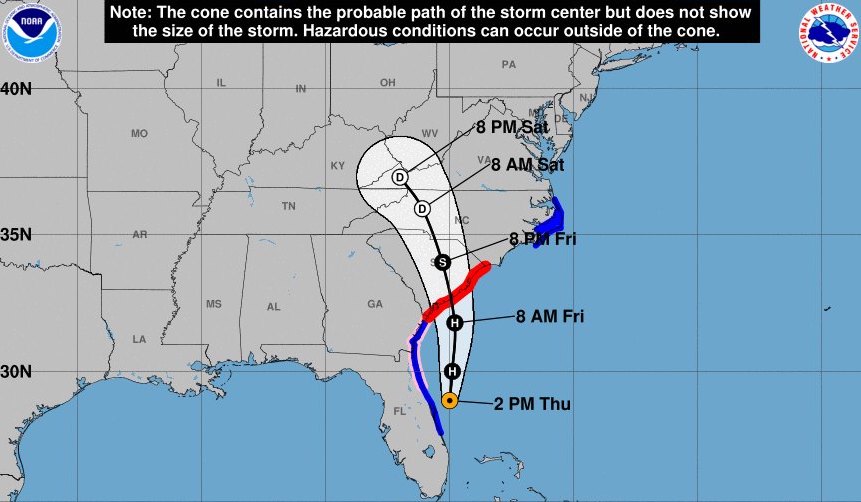
Path trajectory valid until 5 p.m. Source: NOAA NWS National Hurricane Center