

LIVE UPDATES FOR NASSAU COUNTY:
Monday, 6 p.m. — Board of County Commissioners declared a local state of emergency.
Tuesday, 12 a.m. — Fernandina Beach Commission declared a local state of emergency.
Tuesday, 8 a.m. — Emergency Management announced the Shave Bridge is not closed, but may be temporarily shut down if it experiences hazardous conditions. EM also stated there is no evacuation order as of Tuesday morning.
Tuesday, 10 a.m. — Nassau County County School District announces school closures for Thursday, Sept. 29 and Friday, Sept. 30. All afterschool activities will be canceled Wednesday thru Friday.
Tuesday, 12:42 p.m. — The St. Johns River Water Management District will close all District-managed navigational locks, campgrounds and properties, including trails and day use areas Tuesday, Sept. 27 at 7 p.m.
- For the latest on land re-openings, please visit https://www.sjrwmd.com/lands/recreation/announcements/.
- Information and links to flood statements, warnings, river stages, and local government emergency contacts can be found here.
Wednesday, 8 a.m. — Nassau County issued an evacuation order for Zone A and Zone D. Find out which zone you're in with this website.
Wednesday, 12 p.m. — The County will open two shelters at noon:
- Special Needs Shelter
- Hilliard Middle Senior High
- 1 Flashes Drive Hilliard, FL 32046
- General Population and Pet Friendly
- Callahan Middle School
- 450121 Old Dixie Highway Callahan, FL 32033
Wednesday, 3:42 p.m. — The County suspends driving on beaches and the City prohibits beach parking at Seaside Park.
LOCAL RESOURCES:
To report power outages, contact these utility providers:
- FPUC Florida Public Utilities Company
- https://fpuc.com/electric/report-outage/
- (800) 427-7712
- FPL Florida Power & Light
- www.fpl.com/support/report-concerns.html
- (800) 468-8243
- OREMC Okefenoke Rural Electric Membership Corp
- www.oremc.com/outage-center
- (800) 262-5131
To report water or wastewater outages:
- NAU Nassau Amelia Utilities
- www.nassaucountyfl.com/236/Nassau-Amelia-Utilities-NAU
- (904) 530-6903
- JEA
- https://www.jea.com/Outage_Center/
- (904)665-6000
To report property damage:
Fill out this form with the Nassau County Sheriff's Office.
"If the damage you notice may be life-threatening or dangerous to public safety (e.g., live power lines down, large branches or other debris in the road) please call 904-225-5174 or 9-1-1 so that emergency personnel can be dispatched to secure the area." – Emergency Management
CURRENT WATCHES AND WARNINGS:
A Storm Surge Watch and Tropical Storm Watch are in effect for Coastal Camden, Coastal Duval, Coastal Flagler, Coastal Glynn, Coastal Nassau, Coastal St. Johns, Eastern Clay, Eastern Putnam, Inland St. Johns, and South Central Duval
A Tropical Storm Watch is in effect for Bradford, Central Marion, Eastern Alachua, Eastern Marion, Gilchrist, Inland Flagler, Trout River, Western Alachua, Western Clay, Western Duval, Western Marion, and Western Putnam
STORM INFORMATION:
- About 580 miles south-southwest of Jacksonville FL
- 22.3N 83.7W
- Storm Intensity 125 mph
- Movement North or 355 degrees at 12 mph
SITUATION OVERVIEW:
Hurricane Ian, located near 22.3 north, 83.7 west at 5 AM EDT this morning, will continue to move north today, then north-northeast Wednesday. On this track, Ian is forecast to move into the eastern Gulf of Mexico later today and approach the west coast of Florida Wednesday and Thursday. Maximum winds are currently near 125 mph with higher gusts.
A tropical storm watch remains in effect along the southeast GA and northeast FL coastal counties as well as Bradford, Gilchrist, Putnam, Marion, and Eastern Clay counties. A storm surge watch is in effect for the entire coast, as well as the St Johns River.
The start of tropical storm winds may begin as early as Wednesday across north central FL and northeast FL, and Wednesday night over southeast GA coastal areas.
Increasing rain chances are expected Tuesday from south to north, with more rain and rain squalls and possibly embedded thunderstorms occurring Wednesday through Friday. Heavy rainfall and possible flooding is to be expected, with additional flood watches likely required. There is a concern for isolated tornadoes across parts of northeast and north central FL through at least Thursday.
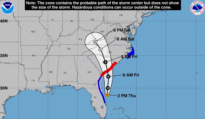
Path trajectory valid until 5 p.m. Source: NOAA NWS National Hurricane Center